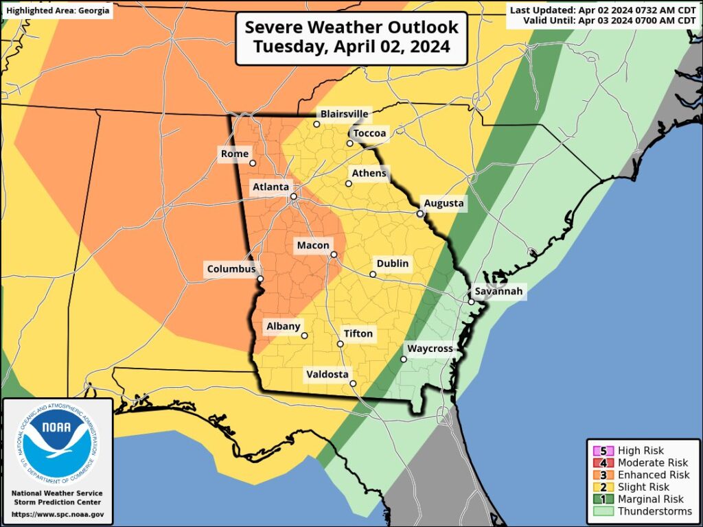
The latest forecast have increased the risk to Coweta County Tuesday Night from Severe Weather, with the last update from the National Weather Service’s Storm Prediction Center increasing the Day 1 outlook from Slight Risk ( 2 of 5 ) to Enhanced Risk ( 3 of 5 ).
April 2nd SPC Outlook Day 1 - Severe Risk
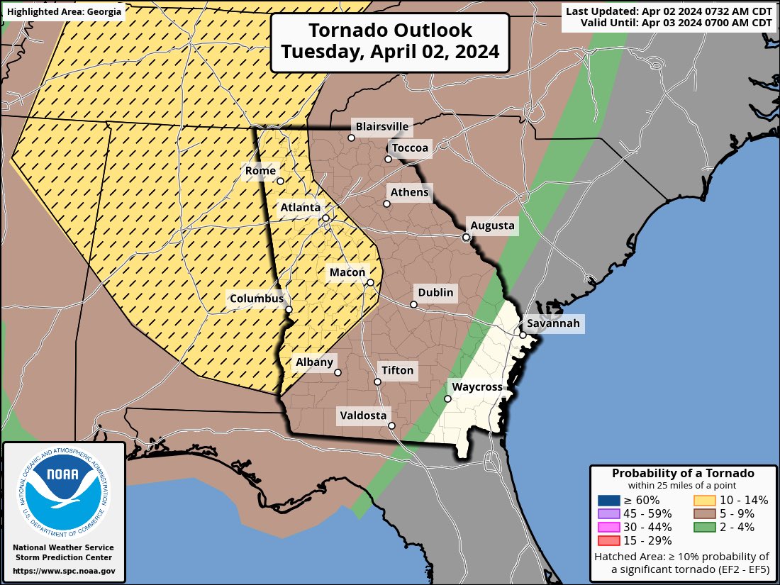
April 2nd SPC Outlook Day 1 - Tornado Probability
They’ve also increased the risk of tornado’s in the area to 10% to 14% ( Hatched ). This means there is a 10% to 14%chance of a tornado within 25 miles of any given point within the notated area ( in yellow ).
When this is combined with the “hatching” as we see with this outlook it means that there’s a greater then 10% probability of a significant tornado, defined as an EF-2 to EF-5 within the notated area. The highest risk of the long track, highly destructive tornados we’ve all come to fear remains to our north in the Ohio Valley.
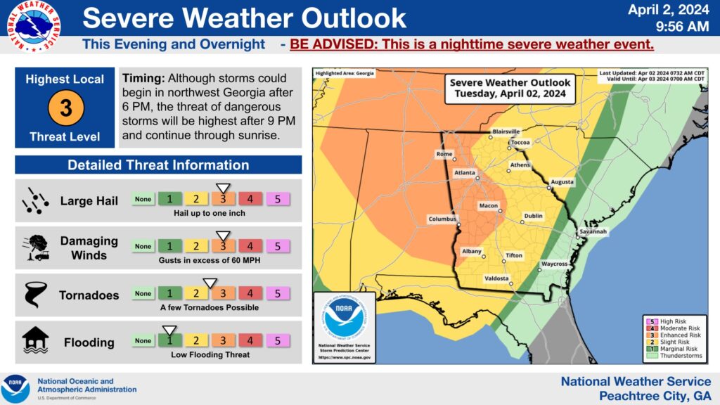
Primary Threats to Coweta County
The following are the most likely threats to impact Coweta County overnight.
Strong Winds – Winds with gusts in excess of 60 MPH are expected to impact the area as storm system moves through the area. This is strong enough to down trees and power lines as well as create damage through unsecured objects flying through the air.
Hail – The storm system has the ability to generate large hail and cause significant damage to items from homes to vehicles.
Heavy Rain – Heavy Rain is expected to impact the area as the storm system moves through the area.
Timeline of Impact to Coweta County
Current forecast have the strom system impacting the area as early as 11 PM this evening and lasting through 3 AM tomorrow morning.
Preperation
It is vital that everyone remains weather aware throughout the night tonight. While we all hope that the perdictions are wrong and we don’t see an impact, it’s always a better idea to be prepared and remain vigil. It may save your life and the life of your family. Below are a few things to remember as we grow closer to the storms arrival.
Charge everything. From your cell phone to your rechargeable flashlights, make sure that everything is plugged in and ready to go if and when needed.
Ensure you have multiple sources to receive warnings and updates regarding the weather. Storms often take out the power and internet to residecnece, make sure to have a cell phone or other devices ready to go and set up to alert you before the storms hit.
Secure everything outside your house, from trash cans to deck chairs make sure that you bring in items that could be moved by heavy winds and damage your house or vehicle.
Plan and discuss with your family members or co-workers what to do incase certain events occur. If the power goes out, who gets the flashlights? If a tornado warning is issued, where are you going and who’s grabbing what on the way. Forethought and planning can prevent tragedies and ensure the best possible outcome if the worst occurs.
Resources
While making sure to keep up with your favorite weatherman and local media is always important, here are some further resources that will help you in preparing for the spring storm season.
Coweta Alerts is a service provided free of charge to the citizens of Coweta County and allows the Coweta County Emergency Management Agency to broadcast life-saving information during emergencies.
With a simple signup process on the website you can choose to receive alerts by receiving a text message, phone call and email – or all three if you wish. It also allows you to receive important information like road closures due to accidents, active shooter alerts and much more.
I’ve personally used Coweta Alerts for years and swear by the speed and accuracy it provides as well as the ability to customize how you interact with it.
The NCST Weather Group is a Facebook Group with one goal. To provide the community with information regarding the weather and how it will impact Coweta County. It’s a free resource open to any with a Facebook account. We only post weather-related content when there is an upcoming or active threat to the community.
Unlike other Facebook Groups, we don’t have spam content – the only post to the group are made by NCST staff or in some rare occasions, approved by NCST Staff.
With over 12,000 local community members, the NCST Weather Group allows NCST to get you important information, quickly. If that’s something that interest you, join today!
NCST is a service provided to the community by R41D41 Industries, LLC. When information is power, we believe the information should be in the hands of the community.